سندھ کا سیلاب جو انڈس ڈیلٹا کے لیے خوشحالی کا پروانہ ہوتا ہے
ان دنوں سندھ ڈیلٹا کے لوگ بہت خوش ہیں کیونکہ سیلابی پانی سے تمر کے جنگلات بڑھے گے، جھینگوں اور مچھلیوں کی پیداوار بڑھے گی اور میٹھا پانی خوشحالی لائے گا۔
ابوبکر شیخ شائع September 19, 2025
Written by: Abu Bakar Shaikh.
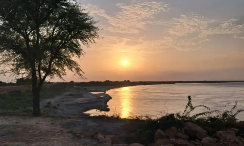
ہم جب ننگر ٹھٹہ سے نکلے تھے تو ابھی سورج طلوع نہیں ہوا تھا، مسلسل بارشوں کی وجہ سے تاحدِ نگاہ مکلی کی پہاڑی، راستے، تعمیرات بھیگے سے دکھائی دے رہے تھے۔ مون سون کا برساتی سلسلہ 4 دن خوب برسنے کے بعد ختم ہو گیا تھا مگر دھوپ کم نکلنے کی وجہ سے نظر جہاں تک جاتی ہر منظر بھیگا نظر آتا جبکہ سمندر کے نزدیک ہونے اور پانی کی نظر نہ آنے والی بوندوں کی وجہ سے منظرنامے پر ہلکی نیلے رنگ کی ایک تہہ بچھی ہوئی نظر آرہی تھی۔
ہم نے ٹھٹہ شہر میں ایک ہوٹل پر ناشتہ کیا دو دو کپ شیریں چائے کے اُنڈیلے اور جب شہر سے شاہ بندر اور کیٹی بندر کے لیے نکلے تو راستوں کے کناروں پر پانی تھا۔ مگر راستے کے کناروں پر موجود کیکر کے درختوں پر بہار چھائی ہوئی تھی۔
موجودہ دنوں پر بات کرنے سے پہلے سندھ کے سمندر کنارے کے متعلق ابن بطوطہ کی کچھ باتیں میں آپ کو سنانا چاہتا ہوں تاکہ موجودہ زمانے ک تصویر ہمیں صاف نظر آئے۔ ابن بطوطہ 1333ء یعنی آج سے 652 برس پہلے سیہون سے سندھو دریا کے راستے انڈس ڈیلٹا میں اپنے ایک دوست کے ساتھ آیا تھا۔ وہ اپنے سفرنامے میں تحریر کرتے ہیں کہ ’سندھو دریا دنیا کے بہت بڑے دریاؤں میں شمار کیا جاتا ہے جس طرح مصر کی زراعت کا دار و مدار نیل کی تغیانی پر ہے، اسی طرح یہاں کے باشندے بھی اس کی طغیانی پر جیتے ہیں‘۔
بالکل ایسی بات عبدالرحیم خان خاناں نے 1592ء میں کہی تھی جب وہ اکبر کے حکم کو مانتے ہوئے ٹھٹہ پر قبضہ کرنے آیا تھا۔ اس نے کہا کہ جنوبی سندھ میں پانی کی نہروں کا ایک جال بچھا ہوا ہے، بالکل اسی طرح جس طرح کسی زمانے میں بغداد نہروں کی بہتات کی وجہ سے مشہور تھا۔ یہاں بہت سارے گھاٹ ہیں اور سمندری کنارہ چھوٹی بڑی بندرگاہوں سے بھرا پڑا ہے۔ دھان، گنا، نیر یہاں بہت اُگایا جاتا ہے۔ جھیلیں بہت ہیں جن کی وجہ سے مچھلی اور پرندوں کی فراوانی ہے۔
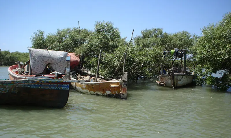
دریائے سندھ کا کنارہ
ابن بطوطہ کے دنوں میں سندھو دریا کا مرکزی بہاؤ، برہمن آباد سے شمال اور مغرب میں دو حصوں میں تقسیم ہوتا تھا۔ ایک بہاؤ جنوب میں نصرپور کے مشرق سے، جنوب مغرب میں ٹنڈو محمد خان کے قریب سے گزرتا ہوا ٹھٹہ کے شمال میں دیبل اور لاڑی بندر کے شمال میں جاکر سمندر میں گرتا تھا۔
ابن بطوطہ لاڑی بندر کے متعلق لکھتے ہیں کہ ’یہ خوبصورت شہر سمندر کے کنارے واقع ہے۔ قریب ہی سندھو دریا سمندر میں جا گرتا ہے۔ یہ شہر بڑی بندرگاہ ہے۔ یہاں یمن اور فارس کے جہاز اور تاجر زیادہ ہوتے ہیں، اس لیے یہ شہر بہت مالدار ہے اور اس کا محاصل بھی زیادہ ہے۔ علاء الملک مجھ سے کہتے تھے کہ اس بندر کا محاصل 60 لاکھ دینار ہے۔ امیر الملک کو اس کا 20واں حصہ ملتا ہے باقی مرکزی حکومت میں جمع ہوتا ہے’۔
ہم جب کوٹری ڈاؤن اسٹریم کے الفاظ استعمال کرتے ہیں تب ہم انڈس ڈیلٹا کی بات کر رہے ہوتے ہیں اور کوٹری کے جنوب میں ہزاروں گاؤں اور لاکھوں انسان بستے ہیں جن کا ذریعہ معاش دریا کے بہاؤ پر ہے۔ جب دریا کے بہاؤ کو روکنے کی کوشش کی جاتی ہے تب پانی کی جگہ تیز ریت بہتی ہے اور وہاں رہنے والے لوگ اپنے گاؤں خالی کرکے نقل مکانی کے درد کی گٹھڑیاں اپنے سینے پر رکھ کر بھٹکتے پھرتے ہیں۔
پانی کی روکنے کی داستان کی ابتدا 1830ء میں ہوئی جب ایسٹ انڈیا کمپنی نے یہاں آب پاشی کا نظام بنایا کہ زراعت زیادہ ہو اور اُن کے کارخانوں کو خام مال مسلسل ملتا رہے۔ 1932ء میں انگریزوں نے ’سکھر بیراج‘ تعمیر کیا۔ یہ سمجھیں کہ دریا کی خوبصورت دیوانگی کو روکنے کی یہ پہلی کوشش تھی۔ پھر 1955 میں ’کوٹری بیراج‘ بنا، 1967ء میں ’منگلا‘ اور پھر 1976ء میں ’تربیلا ڈیم‘ بنا۔ ان تمام منصوبوں کے منفی اثرات انڈس ڈیلٹا پر پڑنے تھے اور پڑے بھی۔
ڈاؤن اسٹریم دریا کا وہ علاقہ ہوتا ہے جہاں دریا کا سفر اختتام کو پہنچتا ہے۔ یہاں فطرت کی رنگارنگی کا اپنا ایک الگ حُسن ہے۔ جنوبی سندھ کی سمندر کنارے والی زمین کو دریا کی مٹی اور ریت نے بنایا ہے۔ جہاں کا منظر نامہ پورے ملک سے مختلف ہے کہ یہاں جھیلوں کی بہتات ہے (تھی) اور کیوں نہ ہو آخر دریائے سندھ کا ہزاروں کلومیٹرز کا سفر یہاں اس ساحلی پٹی پر آکر جو ختم ہوتا ہے۔
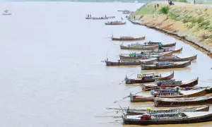
سمندر تک پہنچنے کے لیے جتنے راستے اور بہاؤ دریائے سندھ نے تبدیل کیے ہیں وہ کسی دوسرے دریا نے شاید ہی کیے ہوں۔ ’انسائیکلوپیڈیا سندھیانا‘ اس حوالے سے تحریر کرتی ہے کہ ’دریائے سندھ کے سفر کی آخری منزل سے آگے سمندر تک کافی تعداد میں کھاڑیاں یا کریکس (Creeks) جاتی ہیں۔ جنوب مشرق میں ’سیر‘ نامی کھاڑی ہے جو پانی میں پاک و ہند سرحد کا کام کرتی ہے۔ اس کے علاوہ کھارک، کوچی واڑی، کاجھر، مل، کانہر، ادھیاڑی، سنہڑی، گھوڑو، کھوبر، قلندری، مٹنی، ترچھان، حجامڑو، چھان، دبو، پئٹانی، کھائی، وڈی کُھڈی، ننڈھی کُھڈی، پھٹی، کورنگی اور گزری کریکس ہیں‘۔
آہستہ آہستہ سمندر کی جانب جاتے دریا کے پانی میں کمی آچکی ہے جس کی وجہ سے مقامی لوگوں کے لیے سیلاب رحمت ہوتا ہے
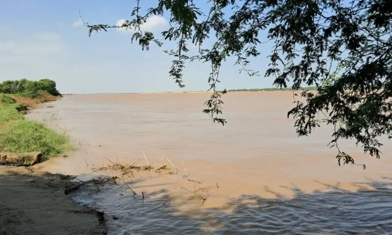
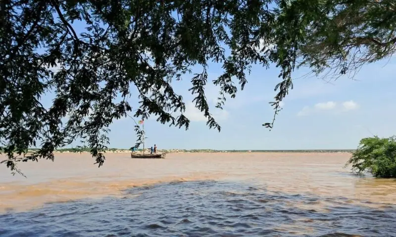
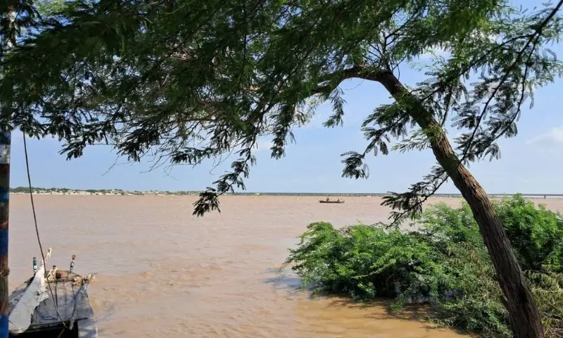
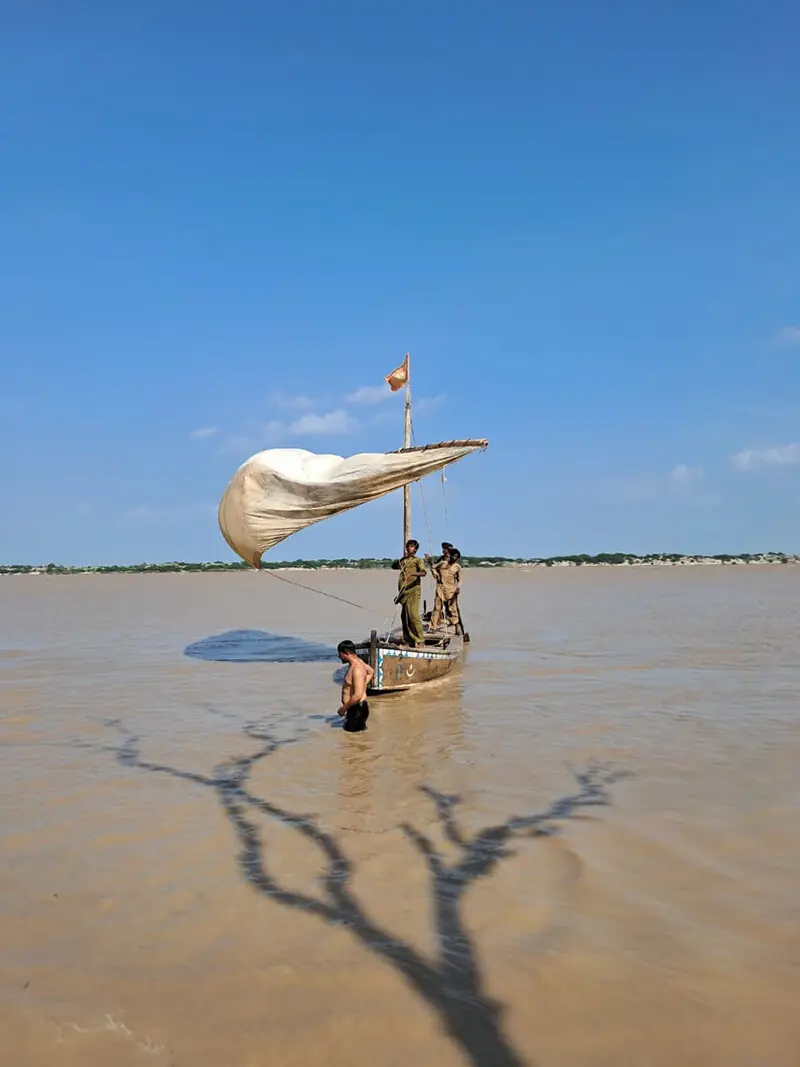
یہ کھاڑیاں وہ راستے ہیں جو دریا سمندر تک پہنچنے کے لیے جنوبی سندھ میں آ کر بناتا ہے۔دریاؤں کی دو اقسام ہیں۔ ایک وہ جن میں ریت اور مٹی کم آتی ہے اور دوسرے وہ جو اپنے ساتھ بڑی مقدار میں ریت اور مٹی لاتے ہیں۔ ایسے دریاؤں میں ’دریائے نیل‘ اور ’دریائے سندھ‘ قابلِ ذکر ہیں۔ ان دونوں میں سے دریائے سندھ اپنے ساتھ سب سے زیادہ زرخیز ریت اور مٹی لانے والا دریا رہا ہے۔ اگر آپ اس تحریر میں شامل تصاویر کو دھیان سے دیکھیں گے تو آپ کو نظر آئے گا کہ پانی کتنا گاڑھا اور مٹیالا ہے۔ یہ پانی زرخیز ریٹ اور خوراک کی ذرات سے بھرا پڑا ہے۔
دریا اپنی ریت سے جو زمین بناتا ہے، ہم اسے ڈیلٹا کہتے ہیں۔ دریا زمین کیسے بناتا ہے؟ میں مختصراً آپ کو بتاتا ہوں۔
دریا کا پانی سمندر کو آگے آتا دیکھ کر چھوٹے پنکھے (بادکش) کی صورت میں پھیل جاتا ہے اور اپنے ساتھ لائی ہوئی ریت پھیلاتا جاتا ہے جو دھیرے دھیرے سے زمین بنتی جاتی ہے اور جیسے جیسے زمین بنتی جاتی ہے سمندر پیچھے کی جانب ہٹتا چلا جاتا ہے مگر اس کی سطح وہی رہتی ہے۔ جب تیز ہواؤں کے دنوں میں سمندر کی مدافعت بڑھتی ہے تو دریا شاخوں میں تقسیم ہو جاتا ہے لیکن اپنے ساتھ لائی ہوئی ریت سمندر کے اندر پھینکتا رہتا ہے۔ اسی طرح سمندر کے اندر ریت کے ٹیلے بنتے جاتے ہیں اور زمین بنتی جاتی ہے۔
اس حوالے سے ہم یہ بخوبی کہہ سکتے ہیں کہ ماضی میں جنوبی سندھ کا مشرق کی جانب والا حصہ (بدین) ایکٹیو ڈیلٹا تھا اور اب مغرب کی طرف (ٹھٹہ) والا حصہ ایکٹیو ڈیلٹا ہے۔
ایک اندازے کے مطابق، جب دریائے سندھ میں طغیانی آتی تھی تو اس طغیانی کے 100 دنوں میں یہ ریت کے 11کروڑ 90 لاکھ معکب گز سمندر کی طرف لے چلتا ہے۔ اگر اس ریت کا مقابلہ ہم نیل ندی سے کریں جو خود ایک زیادہ ریت لانے والا دریا ہے تو یہ پورے ایک برس میں 4 کروڑ معکب گز ہے اور ہم جانتے ہیں کہ دریائے سندھ میں ریت کی مقدار دریائے نیل سے تین گنا زیادہ ہے۔
پانی کا ریلا اپنے ساتھ ریت لاتا ہے
جنرل ہیگ اپنی کتاب ’انڈس ڈیلٹا کنٹری‘ میں دریا سے بنی ہوئی نئی زمین کے متعلق تحریر کرتے ہیں، ’برٹش راج کے بعد سمندر کی طرف زمین کے بڑھ جانے کے متعلق جاننے کے لیے ہماری بڑی دلچسپی رہی۔ ہم نے اس پر سروے بھی کیے اور اس نتیجے پر پہنچے ہیں کہ دریائے سندھ جن مختلف ندیوں کی صورت میں سمندر کی طرف سفر کرتا سمندر سے جا ملتا ہے، وہاں نئی زمین بڑی تیزی سے بن رہی ہوتی ہے اور سمندر کو مسلسل پیچھے دھکیل رہی ہوتی ہے۔
’ہم نے پہلے 1877ء میں اس پر کام کیا تھا۔ جس سے ہمیں پتا لگا کہ گزشتہ 10 برسوں میں ان نہروں کے سمندر میں پانی ڈالنے سے ساڑھے تین مربع میل نئی زمین بنی ہے۔ اور زمین بڑھنے کی رفتار ہر بہاؤ میں ایک جیسی نہیں ہوتی۔ کہیں زمین زیادہ بنتی ہے اور کہیں کم‘۔
انڈس ڈیلٹا اپنی زرخیزی کے حوالے سے خوشحال بھی تھی اور مشہور بھی۔ دھان اُگانے کے لیے اتنی محنت نہیں کرنی پڑتی تھی۔ دھان کے بیج زمینوں میں ڈال دیے جاتے اور دھان کی فصل کے جیسے جنگل اُگ آتے۔ اس کے متعلق جیمز میکمرڈو لکھتے ہیں، ’پانی کے ساتھ دھان بھی بڑھتی جاتی، کسی علاقے میں تو یہ تین سے چار فٹ تک بڑی ہو جاتی‘۔ اور دھان اتنی اراضی میں ہوتی کہ فصل کی کٹائی کے لیے کَچھ اور ملتان سے لوگ یہاں فصل کی کٹائی کے لیے آتے۔
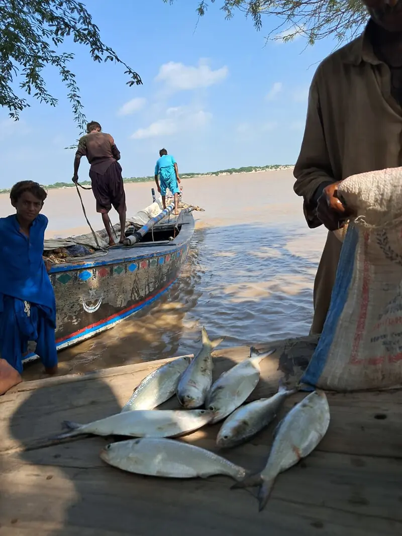
دریا میں ماہی گیر مچھلیاں پکڑتے ہوئے
19 ویں صدی کی ابتدا میں ڈیلٹا کے متعلق جیمس برنس لکھتے ہیں کہ ’یہاں کے مرکزی بہاؤ اور دیگر ندیوں میں سفر کرتے آپ کو پرندوں کی میٹھی آوازیں سننے کو ملیں گی۔ کناروں پر آپ کو گنے کے کھیت ملیں گے جنہیں پانی دینے کے لیے رہٹوں کا استعمال عام ہے۔ ان رہٹوں کو اونٹ اور بیل بھی کھینچتے دکھائی دیتے ہیں۔ یہاں ٹھنڈے دنوں میں پرندوں کی اتنی بہتات ہے کہ اس کا اندازہ کرنا مشکل ہے۔ مچھلی کے شکار کی تو کیا بات ہے، ایسا لگتا ہے کہ مچھلی پیدا ہی یہاں ہوئی ہے۔ یہاں کیکر اور لئی کے بڑے درختوں کے جنگل ہیں جو یقیناً ایک ڈیلٹا کی خوبصورتی کے زیور ہیں‘۔
Empires of the Indus کی مصنفہ Alice Albinia ڈیلٹا کی تباہی کے متعلق تحریر کرتی ہیں کہ ’1958ء میں کوٹری بیراج مکمل ہونے کے بعد 3500 کلومیٹر پر پھیلی ہوئی انڈس ڈیلٹا 250 کلومیٹر تک سُکڑ گئی۔ پانی صرف نام کو سمندر کو جاتا تھا۔ میٹھے پانی کی کمی کی وجہ سے تمر کے جنگل اجڑ گئے، چاول کی فصلیں دینے والی زمینیں سفید نمک میں بدل گئیں۔ کاشتکاروں کے پاس مچھلی کے شکار کے سوا اور کوئی چارہ نہیں بچا‘۔
ڈیلٹا کی اُجڑتی ہوئی دنیا کے متعلق محمد علی شاہ تحریر کرتے ہیں کہ ’گزشتہ کئی برسوں سے حکومت، آبپاشی کے ماہرین، ماحولیاتی ماہرین اور سول سوسائٹی کے درمیان یہ بات زیربحث ہے کہ انڈس ڈیلٹا کے لیے کوٹری ڈاؤن اسٹریم سے کتنے پانی کی ضرورت ہے۔ ماحولیات پر کام کرنے والی عالمی تنظیم ’آئی یو سی این‘ کی تحقیق کے مطابق، تمر کے جنگلات اور سمندر کو آگے بڑھنے سے روکنے کے لیے 2 کروڑ 70 لاکھ ایکڑ فٹ پانی کی ضرورت ہے۔
’ہم جو ماہی گیروں کے لیے کام کرتے ہیں تو ہم یہ چاہتے ہیں کہ 35 ملین ایکڑ فٹ (ایم اے ایف) پانی کی ضرورت ہے جبکہ 1991ء کے معاہدے کے مطابق ڈاؤن اسٹریم میں ایک کروڑ ایکڑ فٹ پانی چھوڑا جانا تھا مگر اس پر بھی عمل نہیں کیا گیا۔ پاکستان آب پاشی نظام پر 3 کروڑ 50 لاکھ ایکڑ زراعت ہوتی ہے، اس کے لیے دریائی بہاؤ پر پانی جمع کرنے کے تین ڈیم بنائے گئے ہیں جن میں 20 ایم اے ایف تک پانی ذخیرہ کیا جاتا ہے۔
کھارے پانی نے ڈیلٹا میں تمر کے جنگلات اجاڑ دیے ہیں
’اس کے علاوہ 12 لنک کینال تعمیر کئے گئے ہیں، ایک تخمینہ کے مطابق دریائے سندھ کا سالانہ بہاؤ سراسری 150 ایم اے ایف ہے۔ اب اس تمام صورت حال کو دیکھیں تو سارا نزلہ آپ کو کوٹری ڈاؤن اسٹریم پر گرتا نظر آئے گا جس کی وجہ سے لاکھوں ایکڑ زرعی زمین برباد ہوئی ہے اور ہو رہی ہے۔
’دریا کا میٹھا پانی سمندر کے آگے بڑھتے ہوئے پانی کو روکتا ہے بلکہ اس کو پیچھے دھکیلتا ہے، تمر کے جنگلات کو اُگاتا ہے جو ایک دیوار کی طرح ساحل کے میدانی علاقوں کو تحفظ کا کام کرتے ہیں۔
’ہم جو Sub-Tropical Country میں رہتے ہیں تو سب ٹراپیکل کنٹریز کا درجہ حرارت بھاری ہوتا ہے، اب ہمارے ملک کے درجہ حرارت کو فقط دریائے سندھ کا تازہ پانی ہی برقرار رکھ سکتا ہے۔
’جب تازہ پانی ڈیلٹا میں داخل ہوتا ہے تو اس کے ساتھ ریت بھی آتی ہے اور اس ریت میں غذائی اجزا ہوتے ہیں جنہیں ہم نیوٹرنٹس بھی کہتے ہیں۔ یہ نیوٹرنٹس مچھلی کو پروٹین اور خوراک مہیا کرتے ہیں اور فطرت اس طریقے سے ایک بریڈنگ شیٹ مہیا کرتی ہے۔ اس لیے سندھ کے سمندر کی مچھلیاں اس پر زندہ رہتی ہیں۔ اگر دریائے سندھ کا پانی وہاں نہیں جائے گا تو وہاں کا درجہ حرارت بڑھ جائے گا اور مچھلیاں زندہ نہیں رہ پائیں گی۔ وہ یا تو مر جائیں گی یا دوسری جگہ چلی جائیں گی۔
پانی سے پہلے پانی کے لیے سرگرداں
’اس لیے میٹھا تازہ پانی آپ کے سمندری درجہ حرارت کو کنٹرول میں رکھتا ہے اور ساتھ میں ایک ’کانٹینینٹل شیلف‘ بھی بناتا ہے۔ سندھ کے ساحل کا ’کانٹینینٹل شیلف‘ 110 کلومیٹر ہے۔ یہ کانٹینینٹل شیلف دریائے سندھ بناتا ہے۔ آپ نے کبھی یہ سوچا ہے کہ بلوچستان کا ساحلی علاقہ تو سندھ کے کوسٹ سے بڑی اراضی میں پھیلا ہوا ہے مگر وہاں مچھلی سندھ کے ساحل سے کم کیوں ہے؟ وہ اس لیے ہے کیونکہ وہاں کا کانٹینینٹل شیلف فقط 30 سے 35 کلومیٹر تک ہے۔
’اس سے یہ ظاہر ہوتا ہے کہ جتنا یہ شیلف وسیع ہوگا، اتنی زیادہ مچھلی وہاں ہوگی اور ساتھ میں اس سلٹ کی وجہ سے تمر کے جنگلات کی خوب افزائش ہوتی ہے اور مینگروز کے جنگلات مسلسل پھلنے پھولنے کے عمل میں مصروف رہتے ہیں۔ مگر اب یہاں ایسا کچھ نہیں ہو رہا۔
’دریائے سندھ کی سمت میں تبدیلی اور سمندر میں پانی نہ چھوڑنے کے سبب، اس وقت فقط 70 ہزار ہیکڑز پر تمر بچے باقی رہ گئے ہیں جو ایک زمانے میں لاکھوں ہیکٹرز پر پھیلے ہوئے تھے۔ یہی تمر کے جنگلات مچھلی اور جھینگوں کی جو کمرشل species ہیں ان کی نرسریز ہوتی ہیں۔ اگر ڈاؤن اسٹریم میں پانی نہیں چھوڑا جاتا تو مچھلی کی صنعت برباد ہو جائے گی اور انڈس ڈیلٹا فقط سمندر کا نام نہیں ہے بلکہ اس میں آب گاہیں، قدرتی جنگل اور زراعت بھی آجاتا ہے۔
دریا کنارے تمر کے جنگلات
’1980ء تک ریونیو ڈپارٹمنٹ کی رپورٹ کے مطابق 12 لاکھ زرعی زمین سمندر کے نذر ہوگئی تھیں اور اب تک ڈیلٹا کی 35 لاکھ زرعی زمین یا تو سمندر نگل گیا ہے یا سمندر کے کھارے پانی کی وجہ سے زمینوں نے اپنی زرخیزی گنوادی ہے۔ یہاں تک کہ گھاس کا ایک تنکا تک نہیں اُگتا۔ لاکھوں لوگوں کو انتہائی مجبوری کی حالت میں نقل مکانی کرنی پڑی ہے۔ جھیلوں کا کلچر برباد ہوا ہے وہ الگ جبکہ جنگلی حیات کی سیکڑوں نسلیں تباہ ہوگئی ہیں۔ یہ ایک سانحے سے کم نہیں ہے‘۔
ہم جب کیٹی بندر سے واپسی پر جھالو کی بستی پہنچے تو وہاں کے سماجی کارکن گلاب شاہ سے میں نے سوال کیا کہ موجودہ وقت جو مون سون کا پانی دریائے سندھ کے راستے سمندر میں داخل ہو رہا ہے، اس سے ڈیلٹا کو کچھ فائدہ ہوگا یا نہیں؟ جواب میں اس نے ایک ہلکا سا قہقہہ لگا کر کہا، ’جس طرح ہم کہتے ہیں کہ ’وٹھا بھلا‘ (بارشیں کتنی بھی برسیں وہ نعمت ہیں) تو ہم یہاں کے بسنے والوں کے لیے تو وہ دن عید کے ہوتے ہیں جب دریا میں پانی آتا ہے تب سب کچھ تبدیل ہونے لگتا ہے۔ وہ میدان، جنگل اور چھوٹی بڑی جھیلیں سوکھی ہوتی ہیں، وہ بھر جاتی ہیں اور گھاس اور درختوں میں جان پڑ جاتی ہے۔ سمندر کے کنارے سے کئی کلومیٹر اندر تک سمندر کے پانی کو یہ میٹھا پانی دھکیل دے دیتا ہے۔
’ آپ اگر بگھان (کیٹی بندر اور کھارو چھان سے پہلے ایک چھوٹا سا شہر) سے کھارو چھان جائیں تو سمندر میں آپ کو نمک سے بھرا پانی نہیں ملے گا بلکہ سندھو دریا کا میٹھا پانی ملے گا جسے ہم تو پیاس لگنے پر پیتے ہیں اور یہ میٹھا پانی آپ کو سمندری کنارے سے کئی میل آگے تک ملے گا۔ جہاں جہاں تک یہ میٹھا پانی جائے گا وہاں جھینگے اور دوسری مچھلیوں کی پیداوار میں بے تحاشا اضافہ ہوگا۔ مطلب کے تین ماہ کے بعد سمندر سے مچھلی پکڑنے کا تناسب گزشتہ برس اگر 30 فیصد تھا تو وہاں اب 90 فیصد ہوگا جس سے مقامی لوگوں پر معاشی حوالے سے اچھے دن آنے والا ہیں’۔
ڈیلٹا کے اچھے دن آنے والے ہیں
پانی اور ماحولیات کے حوالے سے جب ٹھٹہ کے محترم انجینئر اوبھایو خشک سے میں نے دریافت کیا تو انہوں نے انتہائی تفصیل سے جواب دیا، ’موجودہ دنوں دریائے سندھ سے تین لاکھ کیوسک جو اندازاً 60 لاکھ ایکڑ فٹ بنتا ہے، وہ مختلف راستوں (کریکس) سے سمندر میں داخل ہو رہا ہے۔ ٹھٹہ کی دولہہ دریا خان پُل سے آتھرکی تک پہنچ کر یہ دو حصوں میں تقسیم ہوتا ہے۔ ایک روہڑو، کھارو چھان سے ہوتا ہوا شاہ بندر پہنچتا ہے جبکہ دوسرا بہاؤ کیٹی بندر سے ہو کر کھوبر کریک پہنچتا ہے وہاں سے تُرچھان اور پھر حجامڑو کریک تک چلا جاتا ہے۔ یہ تقریباً 80 کلومیٹر سے زیادہ علاقہ ہے جس سے میٹھا پانی سمندری پانی کی جگہ لے لیتا ہے۔
’اس سے ماحولیاتی اور خوراک کے حوالے سے فائدہ ہی فائدہ ہے کیونکہ ان دنوں جب میٹھا پانی اور زرخیز ریت تمر کے جڑوں تک پہنچتی ہے تو اس کے پھلنے پھولنے کی رفتار تیز ہو جاتی ہے اور ساتھ میں اس کے بیج اس پانی کے بہاؤ میں دور دور تک جاتے ہیں۔ چونکہ تمر کاربن ڈائی آکسائیڈ بہت زیادہ جذب کرنے والی جھاڑ ہے، اس کا بڑھنا ماحولیات کے لیے سب سے مثبت ہے۔
’اور ساتھ میں ان کے جنگلات کی جڑوں میں جھینگے اور مچھلیاں انڈے دیتی ہیں تو وہاں ریت اور غذائی اجزا سے بھری ریت موجود ہوتی ہے جس سے ان کی پیداوار بڑھے گی۔ ساتھ میں جہاں جہاں سے سندھو دریا آرہا ہے وہاں کے قرب و جوار میں میٹھے پانی کی سطح بڑھائے گا۔ مطلب یہ کہ ان دنوں ڈیلٹا کے لوگ بے تحاشا خوش ہیں‘۔
یہ پانی انڈس ڈیلٹا میں مچھلیاں اور جھینگوں کی پیداوار بڑھائے گا
ہر خطے کی اپنے معروضی حالات اور احساسات ہوتی ہیں۔ پھر لوگ اُن اثاثوں کو مد نظر رکھتے ہوئے اپنے معاشی راستے تلاش کرتے ہیں کیونکہ دو نوالوں کے سوا ایمان اور احترام کا درخت کبھی نہیں اُگتا پھر ان کے روزگار کے وسائل، وہاں موجود منظرناموں اور موسموں کی کوکھ سے وہاں کا کلچر جنم لیتا ہے۔ زبان کو بیان کی طاقت ملتی ہے اور لہجے اور رویے جنم لیتے ہیں۔
وہ لوگ جو ان حالات میں جنم لیتے ہیں، وہیں پر جوان ہوتے ہیں، وہیں پر ان کے اپنوں کے جنازے اُٹھتے ہیں، ان ہی آنگنوں پر خوشیوں کے ڈھول بجتے ہیں، مطلب ہزاروں برسوں کی فطرت، معروضی حالات اور انسان کے میل میلاپ اور ایک دوسرے کو قبول کرکے ایک کلچر پنپ کر جوان ہوتا ہے۔
ہم کسی مچھلی کے شکار کرنے والے کو یہ کیسے کہہ سکتے ہیں کہ آپ سمندر یا جھیل کے کنارے گَنا کیوں کاشت نہیں کرتے؟ یا یہ کہ آپ کے پاس مچھلی کے شکار کے بعد جو وقت ملتا ہے، اس میں ان کناروں پر ضرور گندم کاشت کردیا کریں تو شاید یہ کسی بھی کیفیت میں ممکن نہیں ہوگا۔ تو ایک کلچر ہے جس کو ہم موہانہ کلچر کا نام دیتے ہے۔ ڈیلٹا کے اچھے دن اور ڈیلٹا کے بُرے دن ایک کلچر کو زندہ رکھنے یا برباد کرنے کا کام کرتے ہیں۔
https://www.dawnnews.tv/news/1269557/
DELTA OF SINDH RIVER
Re: DELTA OF SINDH RIVER
Google Translation:
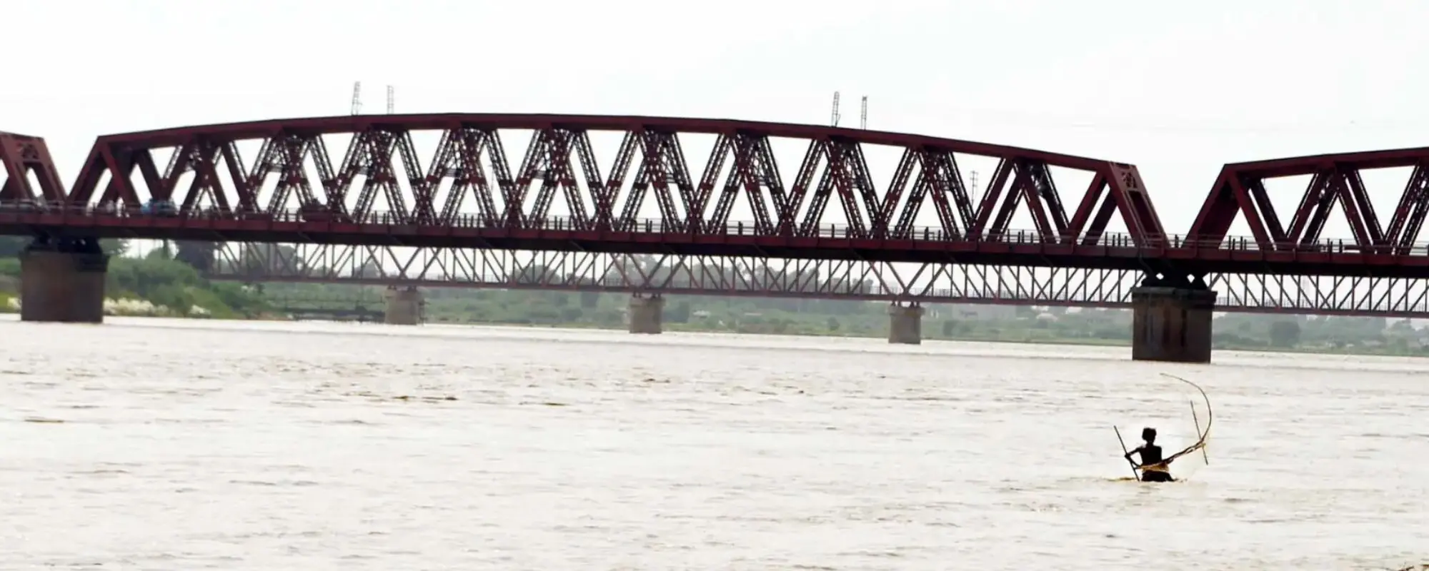
Header: Fisherman Subhan Ali tries his luck at catching pla fish with his small net near the Kotri-Hyderabad railway bridge on the Indus River in Hussainabad—Photo: Umair Rajput
Sindh flood is a blessing for the Indus Delta.
These days, the people of the Sindh Delta are very happy because the floodwaters will grow tamarind forests, increase shrimp and fish production, and fresh water will bring prosperity.
Abu Bakr Sheikh Published September 19, 2025 Updated September 20, 2025
When we left Nangar Thatta, the sun had not yet risen, due to continuous rains, the hills, roads, and buildings of Makli were visible as far as the eye could see. The monsoon rains had ended after 4 days of heavy rain, but due to the lack of sunlight, every scene as far as the eye could see looked wet, while due to the proximity of the sea and the invisible droplets of water, a layer of light blue color was seen on the scene.
We had breakfast at a hotel in Thatta city, poured two cups of sweet tea, and when we left the city for Shah Bandar and Keti Bandar, there was water on the sides of the roads. But spring had covered the kekar trees on the sides of the road.
Before discussing the present day, I would like to tell you some of Ibn Battuta's words about the coastal areas of Indus so that we can see the picture of the present era clearly. In 1333, i.e. 652 years ago, Ibn Battuta came to the Indus Delta from Sehwan via the Indus River with a friend. He writes in his travelogue that 'The Indus River is considered one of the great rivers of the world. Just as the agriculture of Egypt depends on the flood of the Nile, similarly the inhabitants here also live on its flood'.
This is exactly what Abdul Rahim Khan Khan said in 1592 when he came to capture Thatta on the orders of Akbar. He said that a network of water canals is laid in southern Sindh, just as Baghdad was once famous for its abundance of canals. There are many ghats here and the sea coast is dotted with small and large ports. Paddy, sugarcane, and neer are grown in abundance here. There are many lakes, due to which there is an abundance of fish and birds.
The bank of the Indus River
In the days of Ibn Battuta, the main flow of the Indus River divided into two parts, north and west of Brahmanabad. One flow passed east of Nasarpur in the south, near Tando Muhammad Khan in the southwest, and flowed north of Thatta to Debal and north of Lari Bandar before emptying into the sea.
Ibn Battuta writes about Lari Bandar, "This beautiful city is located on the seashore. The Indus River flows into the sea nearby. This city is a large port. There are many ships and traders from Yemen and Persia here, so this city is very rich and its revenue is also high. Alaa-ul-Mulk used to tell me that the revenue of this port is 6 million dinars. Amir-ul-Mulk gets 20% of it, the rest is collected by the central government."
When we use the words Kotri downstream, we are talking about the Indus Delta and south of Kotri, there are thousands of villages and millions of people whose livelihood depends on the flow of the river. When the flow of the river is tried to be stopped, instead of water, quicksand flows and the people living there vacate their villages and wander around, carrying the burdens of displacement on their chests.
The story of water blocking began in 1830 when the East India Company built an irrigation system here to increase agriculture and ensure a continuous supply of raw materials to their factories. In 1932, the British built the 'Sukkur Barrage'. Understand that this was the first attempt to stop the beautiful madness of the river. Then in 1955, the 'Kotri Barrage' was built, in 1967, 'Mangla' and then in 1976, the 'Tarbila Dam' was built. All these projects were supposed to have negative effects on the Indus Delta and they did.
The downstream region of the river is where the river's journey ends. The colorful nature here has its own unique beauty. The coastal land of southern Sindh is made of river mud and sand. The landscape of the place is different from the rest of the country because there are (were) many lakes here and why not, after all, the Indus River's journey of thousands of kilometers ends here on this coastal strip.
The Indus River has changed the number of routes and flows it has taken to reach the sea, which is hardly the case with any other river. 'Encyclopedia Sindhiana' writes in this regard that 'A large number of creeks or streams flow from the final destination of the Indus River to the sea. In the southeast, there is a creek called 'Sir' which acts as the water border between Pakistan and India. Apart from this, there are Kharak, Kochiwadi, Kajhar, Mal, Kanhar, Adhyari, Sinhari, Ghoro, Khobar, Qalandari, Mitni, Tarchhan, Hajamaro, Chan, Dabo, Paitani, Khai, Wadi Khudi, Nandhi Khudi, Phuti, Korangi and Gizri creeks.'
The water level in the river gradually decreases as it flows towards the sea, making floods a blessing for the local people.
These creeks are the paths that the river makes in southern Sindh to reach the sea. There are two types of rivers. One is those that carry less sand and clay and the other is those that carry a large amount of sand and clay. Among such rivers, the 'Nile River' and the 'Indus River' are noteworthy. Of these two, the Indus River has been the river that has carried the most fertile sand and clay. If you look carefully at the pictures included in this article, you will see how thick and gray the water is. This water is full of fertile sediment and food particles.
The land that a river creates with its sand is called a delta. How does a river create land? Let me tell you briefly.
Seeing the sea coming forward, the river water spreads out in the form of a small fan and spreads the sand brought with it, which gradually forms the land. As the land forms, the sea moves backwards, but its level remains the same. When the resistance of the sea increases during strong winds, the river divides into branches, but continues to throw the sand brought with it into the sea. In the same way, sand dunes are formed inside the sea and the land is formed.
In this regard, we can say with certainty that in the past, the eastern part of southern Sindh (Bedin) was an active delta, and now the western part (Thatta) is an active delta.
According to an estimate, when the Indus River floods, it carries 119 million cubic yards of sand towards the sea in 100 days of the flood. If we compare this sand with the Nile River, which itself is a river that carries more sand, it is 40 million cubic yards in a whole year and we know that the amount of sand in the Indus River is three times more than that of the Nile River.
The water current brings sand with it.
General Haig writes about the new land formed by the river in his book 'Indus Delta Country', 'We have been very interested in knowing about the land extension towards the sea after the British Raj. We have also conducted surveys on this and have come to the conclusion that in the various rivers in which the Indus River travels towards the sea and meets the sea, new land is being formed very rapidly and is constantly pushing the sea back.
"We first worked on this in 1877. From which we found that in the last 10 years, three and a half square miles of new land had been created by the discharge of water from these canals into the sea. And the rate of land growth is not the same in every flow. In some places more land is created and in some places less."
The Indus Delta was both prosperous and famous for its fertility. Paddy did not require much effort to grow. Paddy seeds were put in the fields and a forest of paddy crops grew. James McMurdo writes about this, 'Paddy also grew with the water, in some areas it grew to three or four feet'. And the paddy was so abundant that people from Kutch and Multan would come here to harvest the crop.
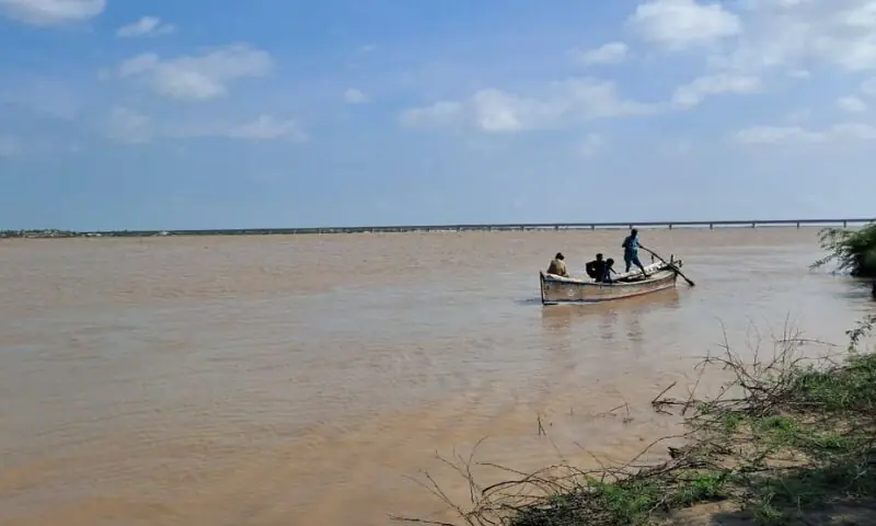
Fishermen catching fish in the river
In the early 19th century, James Burns wrote about the delta that "Traveling along the main stream and other rivers here, you will hear the sweet sounds of birds. On the banks you will find sugarcane fields, which are commonly used for watering. These rickshaws are also seen being pulled by camels and oxen. There is such a multitude of birds here on cold days that it is difficult to estimate it. What is the matter of fishing, it seems that fish were born here. Here are forests of large trees of kakar and lei, which are certainly ornaments of the beauty of a delta."
Alice Albinia, author of Empires of the Indus, writes about the destruction of the delta, "After the completion of the Kotri Barrage in 1958, the Indus Delta, which had spread over 3,500 km, shrank to 250 km. The water only flowed to the sea in name. Due to the lack of fresh water, the tamarind forests were destroyed, the lands that yielded rice crops turned into white salt. The farmers had no choice but to hunt fish."
Regarding the delta's drying up world, Muhammad Ali Shah writes that "For the past several years, there has been a debate among the government, irrigation experts, environmentalists and civil society about how much water is needed downstream from the Kotri River for the Indus Delta. According to research by the international organization working on the environment, 'IUCN', 27 million acre feet of water is needed to prevent the tamarisk forests and the sea from advancing."
"We, who work for the fishermen, want 35 million acre feet (MAF) of water, while according to the 1991 agreement, 10 million acre feet of water was to be released downstream, but this was not implemented either. Pakistan has 35 million acres of agriculture under its irrigation system, for which three dams have been built to store water on the river flow, in which up to 20 MAF of water is stored."
Saltwater has destroyed tamarind forests in the delta.
"In addition, 12 link canals have been constructed. According to an estimate, the annual flow of the Indus River is 150 MAF. Now, if you look at this whole situation, you will see that the entire river is flowing downstream to Kotri, due to which millions of acres of agricultural land have been and are being destroyed."
'The fresh water of the river stops the advancing sea water and even pushes it back, growing tamarind forests that act as a wall to protect the coastal plains.
"We who live in a sub-tropical country experience extreme temperatures. Now only the fresh water of the Indus River can maintain the temperature of our country."
"When fresh water enters the delta, it also brings sand with it and this sand contains nutrients which we also call nutrients. These nutrients provide protein and food to the fish and in this way nature provides a breeding ground. That is why the fish of the Indus Sea survive on it. If the water of the Indus River does not go there, the temperature there will increase and the fish will not be able to survive. They will either die or go to another place."
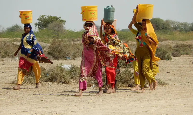
Heads for water before water
"Therefore, the fresh water controls your sea temperature and also creates a 'continental shelf'. The 'continental shelf' of the Sindh coast is 110 km. This continental shelf forms the Indus River. Have you ever wondered why the coastal area of Balochistan is spread over a larger area than the Sindh coast, but why is there less fish there than the Sindh coast? That is because the continental shelf there is only 30 to 35 km.
"This shows that the wider the shelf, the more fish there will be, and at the same time, due to this silt, the tamarind forests grow well and the mangrove forests are constantly engaged in the process of flourishing. But now nothing like that is happening here."
"Due to the change in the direction of the Indus River and the lack of water being released into the sea, only 70,000 hectares of tamarind are left, which once covered millions of hectares. These tamarind forests are nurseries for commercial species of fish and shrimp. If water is not released downstream, the fishing industry will be ruined and the Indus Delta is not just the name of the sea, but also includes wetlands, natural forests and agriculture."
Tamarind forests along the river
"According to the Revenue Department report, by 1980, 1.2 million hectares of agricultural land had been lost to the sea, and by now, 3.5 million hectares of agricultural land in the delta have either been swallowed by the sea or have lost their fertility due to the salt water of the sea. Not even a blade of grass grows here. Millions of people have been forced to migrate. The culture of the lakes has been destroyed, while hundreds of species of wildlife have been destroyed. This is nothing short of a tragedy."
When we reached the Jhalo settlement on our way back from Keti Bandar, I asked Gulab Shah, a social worker there, whether the current monsoon water entering the sea through the Indus River would benefit the delta or not? In response, he said with a slight laugh, "Just as we say 'Vatha Bhalla' (no matter how much rain falls, it is a blessing), for those of us who live here, those days are Eid days. When water comes into the river, everything starts changing. Those fields, forests and small and large lakes dry up, they fill up and the grass and trees come to life. This fresh water pushes the sea water several kilometers from the seashore."
"If you go from Baghan (a small town before Keti Bandar and Kharu Chan) to Kharu Chan, you will not find salt-filled water in the sea, but rather the sweet water of the Indus River, which we drink when we are thirsty, and you will find this sweet water several miles beyond the seashore. Wherever this sweet water goes, the production of prawns and other fish will increase immensely. This means that after three months, if the proportion of fish caught from the sea was 30 percent last year, it will now be 90 percent, which will bring good days to the local people in terms of economy."
Delta's good days are coming.
When I asked the respected engineer Obhayo Khushk of Thatta about water and environment, he replied in great detail, 'Currently, three lakh cusecs from the Indus River, which is estimated to be 6 million acre feet, is entering the sea through various channels (creeks). The river, which is the daughter of Thatta, reaches Atharkhi from the Khan bridge and is divided into two parts. One flows through Rohru and Kharo Chan and reaches Shah Bandar, while the other flows through Keti Bandar and reaches Khobar Creek, from there it goes to Turchahan and then to Hajamro Creek. This is an area of more than 80 kilometers from which fresh water replaces sea water.
"This has environmental and food benefits because these days, when fresh water and fertile sand reach the roots of the tamarind, its growth rate accelerates and its seeds travel far and wide in the flow of this water. Since the tamarind is a shrub that absorbs a lot of carbon dioxide, its growth is most positive for the environment."
"And at the same time, shrimp and fish lay eggs in the roots of their forests, so there is sand and sand full of nutrients, which will increase their production. At the same time, it will increase the level of fresh water in the vicinity of where the Indus River comes from. This means that the people of the delta are immensely happy these days."
This water will increase fish and shrimp production in the Indus Delta.
Every region has its own objective conditions and feelings. Then people find their economic paths keeping in mind those assets because the tree of faith and respect never grows except for two saplings. Then the culture of that region is born from the womb of their livelihood resources, the landscapes and seasons there. Language gets the power of expression and accents and behaviors are born.
Those who are born in these circumstances grow up there, their loved ones are buried there, and drums of joy beat in these courtyards. This means that a culture grows and grows through thousands of years of interaction between nature, objective conditions, and humans, and through accepting each other.
How can we tell a fisherman why don't you cultivate sugarcane on the shores of the sea or lake? Or that you should definitely cultivate wheat on those shores in the time you get after fishing, but perhaps this will not be possible under any circumstances. So there is a culture which we call estuary culture. The good days of the delta and the bad days of the delta work to keep a culture alive or destroy it.
—Photos courtesy: Athar Mustafa Soomro
https://www.dawnnews.tv/news/1269557/
Header: Fisherman Subhan Ali tries his luck at catching pla fish with his small net near the Kotri-Hyderabad railway bridge on the Indus River in Hussainabad—Photo: Umair Rajput
Sindh flood is a blessing for the Indus Delta.
These days, the people of the Sindh Delta are very happy because the floodwaters will grow tamarind forests, increase shrimp and fish production, and fresh water will bring prosperity.
Abu Bakr Sheikh Published September 19, 2025 Updated September 20, 2025
When we left Nangar Thatta, the sun had not yet risen, due to continuous rains, the hills, roads, and buildings of Makli were visible as far as the eye could see. The monsoon rains had ended after 4 days of heavy rain, but due to the lack of sunlight, every scene as far as the eye could see looked wet, while due to the proximity of the sea and the invisible droplets of water, a layer of light blue color was seen on the scene.
We had breakfast at a hotel in Thatta city, poured two cups of sweet tea, and when we left the city for Shah Bandar and Keti Bandar, there was water on the sides of the roads. But spring had covered the kekar trees on the sides of the road.
Before discussing the present day, I would like to tell you some of Ibn Battuta's words about the coastal areas of Indus so that we can see the picture of the present era clearly. In 1333, i.e. 652 years ago, Ibn Battuta came to the Indus Delta from Sehwan via the Indus River with a friend. He writes in his travelogue that 'The Indus River is considered one of the great rivers of the world. Just as the agriculture of Egypt depends on the flood of the Nile, similarly the inhabitants here also live on its flood'.
This is exactly what Abdul Rahim Khan Khan said in 1592 when he came to capture Thatta on the orders of Akbar. He said that a network of water canals is laid in southern Sindh, just as Baghdad was once famous for its abundance of canals. There are many ghats here and the sea coast is dotted with small and large ports. Paddy, sugarcane, and neer are grown in abundance here. There are many lakes, due to which there is an abundance of fish and birds.
The bank of the Indus River
In the days of Ibn Battuta, the main flow of the Indus River divided into two parts, north and west of Brahmanabad. One flow passed east of Nasarpur in the south, near Tando Muhammad Khan in the southwest, and flowed north of Thatta to Debal and north of Lari Bandar before emptying into the sea.
Ibn Battuta writes about Lari Bandar, "This beautiful city is located on the seashore. The Indus River flows into the sea nearby. This city is a large port. There are many ships and traders from Yemen and Persia here, so this city is very rich and its revenue is also high. Alaa-ul-Mulk used to tell me that the revenue of this port is 6 million dinars. Amir-ul-Mulk gets 20% of it, the rest is collected by the central government."
When we use the words Kotri downstream, we are talking about the Indus Delta and south of Kotri, there are thousands of villages and millions of people whose livelihood depends on the flow of the river. When the flow of the river is tried to be stopped, instead of water, quicksand flows and the people living there vacate their villages and wander around, carrying the burdens of displacement on their chests.
The story of water blocking began in 1830 when the East India Company built an irrigation system here to increase agriculture and ensure a continuous supply of raw materials to their factories. In 1932, the British built the 'Sukkur Barrage'. Understand that this was the first attempt to stop the beautiful madness of the river. Then in 1955, the 'Kotri Barrage' was built, in 1967, 'Mangla' and then in 1976, the 'Tarbila Dam' was built. All these projects were supposed to have negative effects on the Indus Delta and they did.
The downstream region of the river is where the river's journey ends. The colorful nature here has its own unique beauty. The coastal land of southern Sindh is made of river mud and sand. The landscape of the place is different from the rest of the country because there are (were) many lakes here and why not, after all, the Indus River's journey of thousands of kilometers ends here on this coastal strip.
The Indus River has changed the number of routes and flows it has taken to reach the sea, which is hardly the case with any other river. 'Encyclopedia Sindhiana' writes in this regard that 'A large number of creeks or streams flow from the final destination of the Indus River to the sea. In the southeast, there is a creek called 'Sir' which acts as the water border between Pakistan and India. Apart from this, there are Kharak, Kochiwadi, Kajhar, Mal, Kanhar, Adhyari, Sinhari, Ghoro, Khobar, Qalandari, Mitni, Tarchhan, Hajamaro, Chan, Dabo, Paitani, Khai, Wadi Khudi, Nandhi Khudi, Phuti, Korangi and Gizri creeks.'
The water level in the river gradually decreases as it flows towards the sea, making floods a blessing for the local people.
These creeks are the paths that the river makes in southern Sindh to reach the sea. There are two types of rivers. One is those that carry less sand and clay and the other is those that carry a large amount of sand and clay. Among such rivers, the 'Nile River' and the 'Indus River' are noteworthy. Of these two, the Indus River has been the river that has carried the most fertile sand and clay. If you look carefully at the pictures included in this article, you will see how thick and gray the water is. This water is full of fertile sediment and food particles.
The land that a river creates with its sand is called a delta. How does a river create land? Let me tell you briefly.
Seeing the sea coming forward, the river water spreads out in the form of a small fan and spreads the sand brought with it, which gradually forms the land. As the land forms, the sea moves backwards, but its level remains the same. When the resistance of the sea increases during strong winds, the river divides into branches, but continues to throw the sand brought with it into the sea. In the same way, sand dunes are formed inside the sea and the land is formed.
In this regard, we can say with certainty that in the past, the eastern part of southern Sindh (Bedin) was an active delta, and now the western part (Thatta) is an active delta.
According to an estimate, when the Indus River floods, it carries 119 million cubic yards of sand towards the sea in 100 days of the flood. If we compare this sand with the Nile River, which itself is a river that carries more sand, it is 40 million cubic yards in a whole year and we know that the amount of sand in the Indus River is three times more than that of the Nile River.
The water current brings sand with it.
General Haig writes about the new land formed by the river in his book 'Indus Delta Country', 'We have been very interested in knowing about the land extension towards the sea after the British Raj. We have also conducted surveys on this and have come to the conclusion that in the various rivers in which the Indus River travels towards the sea and meets the sea, new land is being formed very rapidly and is constantly pushing the sea back.
"We first worked on this in 1877. From which we found that in the last 10 years, three and a half square miles of new land had been created by the discharge of water from these canals into the sea. And the rate of land growth is not the same in every flow. In some places more land is created and in some places less."
The Indus Delta was both prosperous and famous for its fertility. Paddy did not require much effort to grow. Paddy seeds were put in the fields and a forest of paddy crops grew. James McMurdo writes about this, 'Paddy also grew with the water, in some areas it grew to three or four feet'. And the paddy was so abundant that people from Kutch and Multan would come here to harvest the crop.
Fishermen catching fish in the river
In the early 19th century, James Burns wrote about the delta that "Traveling along the main stream and other rivers here, you will hear the sweet sounds of birds. On the banks you will find sugarcane fields, which are commonly used for watering. These rickshaws are also seen being pulled by camels and oxen. There is such a multitude of birds here on cold days that it is difficult to estimate it. What is the matter of fishing, it seems that fish were born here. Here are forests of large trees of kakar and lei, which are certainly ornaments of the beauty of a delta."
Alice Albinia, author of Empires of the Indus, writes about the destruction of the delta, "After the completion of the Kotri Barrage in 1958, the Indus Delta, which had spread over 3,500 km, shrank to 250 km. The water only flowed to the sea in name. Due to the lack of fresh water, the tamarind forests were destroyed, the lands that yielded rice crops turned into white salt. The farmers had no choice but to hunt fish."
Regarding the delta's drying up world, Muhammad Ali Shah writes that "For the past several years, there has been a debate among the government, irrigation experts, environmentalists and civil society about how much water is needed downstream from the Kotri River for the Indus Delta. According to research by the international organization working on the environment, 'IUCN', 27 million acre feet of water is needed to prevent the tamarisk forests and the sea from advancing."
"We, who work for the fishermen, want 35 million acre feet (MAF) of water, while according to the 1991 agreement, 10 million acre feet of water was to be released downstream, but this was not implemented either. Pakistan has 35 million acres of agriculture under its irrigation system, for which three dams have been built to store water on the river flow, in which up to 20 MAF of water is stored."
Saltwater has destroyed tamarind forests in the delta.
"In addition, 12 link canals have been constructed. According to an estimate, the annual flow of the Indus River is 150 MAF. Now, if you look at this whole situation, you will see that the entire river is flowing downstream to Kotri, due to which millions of acres of agricultural land have been and are being destroyed."
'The fresh water of the river stops the advancing sea water and even pushes it back, growing tamarind forests that act as a wall to protect the coastal plains.
"We who live in a sub-tropical country experience extreme temperatures. Now only the fresh water of the Indus River can maintain the temperature of our country."
"When fresh water enters the delta, it also brings sand with it and this sand contains nutrients which we also call nutrients. These nutrients provide protein and food to the fish and in this way nature provides a breeding ground. That is why the fish of the Indus Sea survive on it. If the water of the Indus River does not go there, the temperature there will increase and the fish will not be able to survive. They will either die or go to another place."
Heads for water before water
"Therefore, the fresh water controls your sea temperature and also creates a 'continental shelf'. The 'continental shelf' of the Sindh coast is 110 km. This continental shelf forms the Indus River. Have you ever wondered why the coastal area of Balochistan is spread over a larger area than the Sindh coast, but why is there less fish there than the Sindh coast? That is because the continental shelf there is only 30 to 35 km.
"This shows that the wider the shelf, the more fish there will be, and at the same time, due to this silt, the tamarind forests grow well and the mangrove forests are constantly engaged in the process of flourishing. But now nothing like that is happening here."
"Due to the change in the direction of the Indus River and the lack of water being released into the sea, only 70,000 hectares of tamarind are left, which once covered millions of hectares. These tamarind forests are nurseries for commercial species of fish and shrimp. If water is not released downstream, the fishing industry will be ruined and the Indus Delta is not just the name of the sea, but also includes wetlands, natural forests and agriculture."
Tamarind forests along the river
"According to the Revenue Department report, by 1980, 1.2 million hectares of agricultural land had been lost to the sea, and by now, 3.5 million hectares of agricultural land in the delta have either been swallowed by the sea or have lost their fertility due to the salt water of the sea. Not even a blade of grass grows here. Millions of people have been forced to migrate. The culture of the lakes has been destroyed, while hundreds of species of wildlife have been destroyed. This is nothing short of a tragedy."
When we reached the Jhalo settlement on our way back from Keti Bandar, I asked Gulab Shah, a social worker there, whether the current monsoon water entering the sea through the Indus River would benefit the delta or not? In response, he said with a slight laugh, "Just as we say 'Vatha Bhalla' (no matter how much rain falls, it is a blessing), for those of us who live here, those days are Eid days. When water comes into the river, everything starts changing. Those fields, forests and small and large lakes dry up, they fill up and the grass and trees come to life. This fresh water pushes the sea water several kilometers from the seashore."
"If you go from Baghan (a small town before Keti Bandar and Kharu Chan) to Kharu Chan, you will not find salt-filled water in the sea, but rather the sweet water of the Indus River, which we drink when we are thirsty, and you will find this sweet water several miles beyond the seashore. Wherever this sweet water goes, the production of prawns and other fish will increase immensely. This means that after three months, if the proportion of fish caught from the sea was 30 percent last year, it will now be 90 percent, which will bring good days to the local people in terms of economy."
Delta's good days are coming.
When I asked the respected engineer Obhayo Khushk of Thatta about water and environment, he replied in great detail, 'Currently, three lakh cusecs from the Indus River, which is estimated to be 6 million acre feet, is entering the sea through various channels (creeks). The river, which is the daughter of Thatta, reaches Atharkhi from the Khan bridge and is divided into two parts. One flows through Rohru and Kharo Chan and reaches Shah Bandar, while the other flows through Keti Bandar and reaches Khobar Creek, from there it goes to Turchahan and then to Hajamro Creek. This is an area of more than 80 kilometers from which fresh water replaces sea water.
"This has environmental and food benefits because these days, when fresh water and fertile sand reach the roots of the tamarind, its growth rate accelerates and its seeds travel far and wide in the flow of this water. Since the tamarind is a shrub that absorbs a lot of carbon dioxide, its growth is most positive for the environment."
"And at the same time, shrimp and fish lay eggs in the roots of their forests, so there is sand and sand full of nutrients, which will increase their production. At the same time, it will increase the level of fresh water in the vicinity of where the Indus River comes from. This means that the people of the delta are immensely happy these days."
This water will increase fish and shrimp production in the Indus Delta.
Every region has its own objective conditions and feelings. Then people find their economic paths keeping in mind those assets because the tree of faith and respect never grows except for two saplings. Then the culture of that region is born from the womb of their livelihood resources, the landscapes and seasons there. Language gets the power of expression and accents and behaviors are born.
Those who are born in these circumstances grow up there, their loved ones are buried there, and drums of joy beat in these courtyards. This means that a culture grows and grows through thousands of years of interaction between nature, objective conditions, and humans, and through accepting each other.
How can we tell a fisherman why don't you cultivate sugarcane on the shores of the sea or lake? Or that you should definitely cultivate wheat on those shores in the time you get after fishing, but perhaps this will not be possible under any circumstances. So there is a culture which we call estuary culture. The good days of the delta and the bad days of the delta work to keep a culture alive or destroy it.
—Photos courtesy: Athar Mustafa Soomro
https://www.dawnnews.tv/news/1269557/
Last edited by kmaherali on Sat Sep 27, 2025 4:13 pm, edited 1 time in total.
Re: DELTA OF SINDH RIVER
Farman on Sindh
Many spiritual children here today are from areas of Sindh remote from Karachi, and I want you to know how many wonderful memories I have of my previous visits to Sindh, and how, Insha'Allah, I hope to have an opportunity on my next visit to see those remoter areas. Sindh has a very special place in the history of our Tariqh, and I recollect and remember -- and I am happy at the joy of thinking of -- that very special place that Sindh has in our history. And I would say to the Sindhis here: remain strong on that tradition, keep to that tradition, be regular in the fulfilment of your duties in Jamatkhana and other duties. ( Mowlana Shah Karim, 26th October 2000, Darkhana Karachi Pakistan)
Speech on Sindh
You have paid my family a great honour by inviting me here today to receive an Honorary Doctorate of Laws from this famous centre of learning. I am most grateful to you all, and as a Muslim, it makes me especially happy that this ceremony should be taking place at a university whose development has been so intimately linked with the historic province of Sind.
As you pointed out in your very generous tribute to my forbearers, and particularly my grandfather, both my family and the Ismaili Community have enjoyed close associations with Sind over many centuries. (Speech by His Late Highness Aga Khan IV, Sindh, Pakistan · 6 February 1970 )
-
swamidada786
- Posts: 375
- Joined: Tue Apr 29, 2025 8:56 pm
Re: DELTA OF SINDH RIVER
Thanks Kmaherali for google translation of the article 'Delta of Sindh river'.
Let me include some information related to Ismailis living near flow of Sindhu (Indus). Some 200 years or so, on banks of river near Nasarpur, Tando Muhammad Khan and Mulla Katiyar settled many Ismaili families whose businesses depended on fisheries, and cargo boats running up and down stream of river. Those Ismailis were well settled and rich. When Sindhu river drifted away and changed the direction, Ismailis became jobless and their businesses were ruined. Some families moved to Tando Muhammad Khan and many migrated to Hyderabad and some to Karachi from Nasarpur and Mulla Katiyar around 1920.
In those days main concentration of Sindhi Ismailis were in Thatta district not Karachi. For example, in ketti Bunder (real name kathy Bunder), Sujjawal, Shah Bunder, Tar Khwaja, War Khwaja, Jherruk, and many more pockets of Ismailis still living in those areas. Later on hundreds of Ismaili families moved to Karachi, mostly settled in Kharadar and Meetha dar. In those days population of Ismailis in Karachi was very thin but after 1920 it started increasing.
Re: DELTA OF SINDH RIVER
There is an interesting article on: Jerruk and the Ismailis during the British rule in India at: https://www.ismaili.net/Source/jerruk/1.html
-
swamidada786
- Posts: 375
- Joined: Tue Apr 29, 2025 8:56 pm
Re: DELTA OF SINDH RIVER
kmaherali wrote: Sat Sep 27, 2025 8:25 pm There is an interesting article on: Jerruk and the Ismailis during the British rule in India at: https://www.ismaili.net/Source/jerruk/1.html
With reference to above article, Mumtaz wrote, " It must be known that the Aga Khan had tried to convince Nasir Khan, the Talpur amir of Kalat, to cede Karachi to the British. Nasir Khan refused it; therefore, the Aga Khan disclosed his battle plan to Major James Outram. As a result, the British camp was saved from a night attack. The Aga Khan had also placed his cavalry at the disposal of the British. For his valuable services in Afghanistan and Sind, the Aga Khan was granted an annual pension of 2000 pounds with an honorific title of His Highness".
The pension was not 2000 pounds, but it was 1000 Rupees. It is mentioned by Alijiani Mrs Zawahir Muir in the book
"Tarikh e A'ima e Ismailia part 4, published by Ismailia Association, Karachi Pakistan, 1983; page # 31.
Re: DELTA OF SINDH RIVER
Mowlana Sultan Muhammad Shah mentions the level of service rendered by his grandfather for the British cause in his Memoirs:
In his wanderings of the next few years my grandfather encountered and rendered stout assistance to the British in their process of military and imperial expansion northward and westward from the Punjab. In Sind he raised and maintained a troop of light horse (the descendants of whose survivors were so grave an anxiety to me many years later) and during the latter stages of the first Afghan War, in 1841 and 1842, he and his cavalry were of service to General Nott in Kardahar and to General England when he advanced out of Sind to join Nott. For these services and for others which he rendered to Sir Charles Napier in his conquest of Sind in 1843-1844, my grand father received a pension from the British Government.
It is quite substantial and in my opinion 2000 pounds seems reasonable.
-
swamidada786
- Posts: 375
- Joined: Tue Apr 29, 2025 8:56 pm
Re: DELTA OF SINDH RIVER
Let me refer to Zawahir Muir again. On page # 40 in foot notes of Tarikh e A'ama e Ismailia part 4, she mentioned, I quote," Rupees thousand will be equal to $100". The book was published in 1983 and that time one dollar was equal to 9/10 Pakistani Rupees.kmaherali wrote: Sat Sep 27, 2025 11:10 pm Mowlana Sultan Muhammad Shah mentions the level of service rendered by his grandfather for the British cause in his Memoirs:
In his wanderings of the next few years my grandfather encountered and rendered stout assistance to the British in their process of military and imperial expansion northward and westward from the Punjab. In Sind he raised and maintained a troop of light horse (the descendants of whose survivors were so grave an anxiety to me many years later) and during the latter stages of the first Afghan War, in 1841 and 1842, he and his cavalry were of service to General Nott in Kardahar and to General England when he advanced out of Sind to join Nott. For these services and for others which he rendered to Sir Charles Napier in his conquest of Sind in 1843-1844, my grand father received a pension from the British Government.
It is quite substantial and in my opinion 2000 pounds seems reasonable.
Re: DELTA OF SINDH RIVER
ISMAILI RULE IN SIND AND HIND : http://heritage.ismaili.net/node/10457
ISMAILI RULE IN SIND AND HIND -2 : http://heritage.ismaili.net/node/10458
ISMAILI RULE IN SIND AND HIND -2 : http://heritage.ismaili.net/node/10458
-
swamidada786
- Posts: 375
- Joined: Tue Apr 29, 2025 8:56 pm
Re: DELTA OF SINDH RIVER
"The Abbasid caliph al-Mutamid (d. 279/892) had handed over the charge of Sind to the Saffarid chief, Yaqub bin Layth, in order to divert his intentions from attacking Iraq. As a result, Yaqub bin Layth acquired the power of Sind, Balkh and Tabaristan. He however recited the Abbasid khutba, and was simultaneously responsible to spread Shi'ism in the territories he governed. He died in 265/892, and with his departure, the Muslim territories in Sind had been divided into two main states, i.e., the State of Multan and Mansurah. In 279/892, the State of Multan passed into the hands of an Arab dynasty, called Banu Samah, founded by the clan of Asad.kmaherali wrote: Thu Oct 02, 2025 9:52 am ISMAILI RULE IN SIND AND HIND : http://heritage.ismaili.net/node/10457
ISMAILI RULE IN SIND AND HIND -2 : http://heritage.ismaili.net/node/10458
Meanwhile, Ibn Hawshab had sent al-Haytham in 270/884 from Yamen to Sind for Ismaili propaganda. He operated the Ismaili mission that continued under the charge of different da'is. The early accounts are so meager that nothing can be gleaned about the missionary activities. It is however possible that they had spread in the State of Multan during the period of Samah rule.
With reference to above paragraph, which dynasty first ruled over Multan, Samma or Soomra?
Soomra dynasty ruled Sindh from 1025 to 1351.
Samma eventually overthrew the Soomra to establish their own dynasty in 1351 before being replaced by Arghun dynasty in 1524.
Prince Aga Khan Palace, Jhimpir, Thatta: History and Heritage
AS RECEIVED:
*Prince Aga Khan Palace, Jhimpir, Thatta: History and Heritage*
_Writer: Mir Farooq Baloch_
Located near the historic city of Thatta, at the foothills of the Jhimpir mountains, Prince Aga Khan Palace is an important symbol of Ismaili history and Sindhi culture. This site not only attracts tourists but also opens the pages of history linked to the early 20th century.
*Construction and Background*
Prince Aga Khan Palace was built in the 1920s on the orders of Sultan Muhammad Shah, Aga Khan III. Its purpose was to establish a rest house and spiritual center for the Ismaili community in the Jhimpir area. At that time, the Jhimpir region was already famous for its moderate climate and natural beauty. It is said that Aga Khan III stayed here several times and initiated many projects for the welfare of the local people.
Local stone and traditional Sindhi architectural style were used in the construction of the palace. Its design contains elements of Mughal and Islamic architecture. High walls, spacious rooms, and open courtyards around make it a safe and peaceful place.
*Historical Significance*
This palace was not only a residence but also remained a center for the social and educational work of the Ismaili movement in Sindh. Aga Khan III took many steps for the development of education, health, and agriculture in Sindh. The presence of the palace in Jhimpir opened up employment opportunities and paths to development for the local people.
This place also remained important for the Ismaili Imamat in the 1940s and 1950s. Later, Aga Khan IV also stayed at this palace during his visit to Sindh. For this reason, the place is known as “Prince Aga Khan Palace.”
*Present Situation*
Today, Prince Aga Khan Palace is preserved as a historical heritage. The building has been repaired and maintained with the cooperation of the Government of Sindh and the Aga Khan Development Network. Due to its proximity to the Jhimpir wind power corridor, this place is now becoming important for historical tourism as well as eco-tourism.
When tourists come here, they feel the silence and dignity of the historic building along with Sindh’s natural scenery. The mountains and desert landscape spread around the palace make it a unique place.
*Conclusion*
Prince Aga Khan Palace, Jhimpir, Thatta, is a living example of Sindh’s history, culture, and spiritual heritage. It shows how a personal residence can, over time, be become a memorial for a nation. For the younger generation of Sindh, such places are not only a source of recreation but also a way to connect with history.